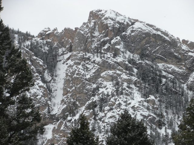
 After two unsuccessful attempts last year, I was finally able to successfully traverse Chestnut Mountain on skis.
 Mike and I made the traverse on Saturday and it was a great day out in the mountains. Rain and unusually warm weather thwarted last year's efforts, but lucky for us it was close to 20 degrees cooler this year. The cool and cloudy day assured that the snow stayed nice throughout outing.
Like last year, the tour started at the Chestnut Mountain trailhead. We estimated the traverse to be approximately seven miles, with about 2,500 feet of skinning in the first 4.5 to five miles. I have biked this route and it can be a bit steep on a bike, so I was pleasantly surprised to find that skinning it was pretty easy. There are a few tight switchbacks in the trees before the ridge, but otherwise if is a straight forward tootle. The ridge offers numerous ups and downs along the way with the high point about half an hour before the Goose Creek Meadow.
The first part of the skin was just okay. Given it's lower elevation, it was not surprising that snow cover was a bit on the thin side with lots of logs and brush sticking out. The trail gets regular use from hikers and snowshoers so rather than a nice skin track, we followed a wide and lumpy path for a good part of the way. The footprints got sparse about an hour into our skin and eventually all that remained were the tracks of one dedicated snowshoer who made it all the way to the ridge! (We were impressed and what to know who this guy/gal is! If you know [Or if it's you] share the story in the comments section of this post.)
There were a few downed trees to cross the closer we got to the ridge with logs and brush continuing to stick out. If you change your mind and decide to bail, hopefully you'll do so before you get to this point because going back to the start from here would not be fun. Once on the ridge, the conditions had better coverage and things turned a lot more wintery. There were a few windy spots along the ridge as there always are, but the wind was never too prolonged, which made for a really pleasant skin.
 We were both surprised at how close the high point is to the Goose Creek Meadow. While we had both been up there many times, on foot and on a bike, the perspective and pacing is totally different on skis. When we finally reached the high point, we were less than 45 minutes to the Goose Creek trailhead. All told, the entire outing took under five hours.
With its proximity to town, safe slopes and straightforward approach, Goose Creek Meadow is a popular backcountry destination for Bozeman skiers. There hadn't been significant snow for a while so while we didn't expect untracked, memorable conditions, we weren't prepared for the tracked-out mess we found. Apparently, snowmobilers are starting to discover Goose Creek Meadow and although their tracks were not abundant, all it took were a few to leave deep ruts in the snow. Add that to the wind effected snow and abundance of ski tracks and the meadow was a wreck. While I have always known Goose Creek Meadow to be a popular destination, this was the most tracked out I've even seen it.
Overall, it was a great day out in the mountains, and I would recommend the Chestnut Mountain Traverse to any avid skier looking for something different. While it won't make the list of epic ski tours of Montana, you will get in plenty of exercise with nice skinning along the ridge and great views of surrounding mountain ranges.
If you go...
Your route: We did it from the Chestnut Mountain parking area to Goose Creek trailhead. This makes for a longer skin up to the ridge but you'll end the trip with a ski down the a pleasant meadow.
To shuttle or not to shuttle? Good question. My instinct was to hitch back to our car at the end of our ski, but we decided on using two cars as the shuttle is relatively short. This was lucky for us as we only saw two parties throughout our entire ski and only few cars were in the parking lot at the end of the day with no people around. It would have been a while if we had to hitch.
 Avalanche hazard: Not really much too worry about with the route I described, but it always a good idea to be aware of what is going on snow and weather-wise. Make sure to check the Gallatin National Forest's avalanche advisory, carry avalanche rescue gear, and only expose one person at a time to avalanche terrain.
For more information: Just Google "Chestnut Mountain Bozeman" and you'll come up with a ton
of references for biking and hiking the trail. These resources should help you get oriented. This is about the best you can hope for as no proper backcountry ski guide for the Bozeman area exists and if it did, few people ever ski this route so it probably wouldn't make the book. If you go, the ridge is not too hard to follow so route finding is relatively easy.
Happy touring! If you get around to doing the traverse, please share your stories below.
~
First part of the story
http://annvinciguerra.blogspot.com/2015/01/girl-vs-mountain-girl-0-mountain-1.html
And one more about backcountry skiing
http://annvinciguerra.blogspot.com/2016/01/west-yellowstone-unexpected-backcountry.html
 |
| Along the ridge |
 |
| The HJ Couloir. Last time it had enough snow to ski was 1978. |

No comments:
Post a Comment