9.5 days, 20K+ vertical feet, 124 miles in the Black Hills
There were many reasons I could have said no to the hike. My biggest backpacking trip prior was 35 miles over three days. I’m fit and do several backpacking trips each summer, but how would my middle age body hold up day after day?
Earlier this year I first learned of the Centennial Trail. My college buddy Jen, who has long been asking me to do the Appalachian Trail with her, was keen to go but I wasn’t 100% convinced. Could I handle it physically and mentally? Would it be safe to travel during the pandemic? Would I have to quarantine when I got home? I prefer to travel abroad – maybe I should save my vacation time for a more exotic trip.
Poison ivy, rattlesnakes, ticks. I seldom have to deal with these things when backpacking in Montana. Most people don't know I’m rather prissy. More reasons not to go.
As spring passed COVID restrictions never eased. Mike and I were forced to cancel our May trip to Croatia and chances for a fall trip abroad seemed remote. The Centennial Trail came up in conversation over July 4 weekend and Mike encouraged me to do it. He even offered to help with resupply along the way. I called Jen and she was in.
The best dates for Jen coincided with the Sturgis Motorcycle Rally. Piles of people and no mask requirement in freedom loving South Dakota. It was going to be hot. Maybe I should back out.
But there were a lot of reasons to go. Hiking the Centennial Trail would be a chance to test myself. Each
day I’d do nothing more than hang out and talk with a dear friend, move, eat, and sleep. I’d carry no more than what I needed. No work or bills or household tasks. It would be life reduced to its most basic form. Additionally, I have always believed that if you put things off until the circumstances are perfect you don’t do much in life.
day I’d do nothing more than hang out and talk with a dear friend, move, eat, and sleep. I’d carry no more than what I needed. No work or bills or household tasks. It would be life reduced to its most basic form. Additionally, I have always believed that if you put things off until the circumstances are perfect you don’t do much in life.
I was in. This would be my first big thru-hike.
~
Mike joined us for day one. We started out in Wind Cave National Park on a hot afternoon. Within the first mile we were up to our waists along an overgrown, poison ivy lined trail. It was not an inspiring start to the trip, but soon the terrain opened, and the rolling landscape was reminiscent of a mini-Yellowstone. My spirits lifted.
Clouds cover grew and thundered rumbled off in the distance for a long time before the skies opened up right as we got to our stopping point for the night. We huddled in rain gear as the storm moved closer. Lightening flashed in distance, and thunder rumbled, some booms coming close. Pebble size pelts of hail stung our bodies. I was chilled but waiting out the storm with my best college buddy and my partner was reassuring. I was at the beginning of a two-week holiday from work; a chance to be outdoors for days, exploring a new landscape. Discomfort paired with exhilaration and I was extremely happy.
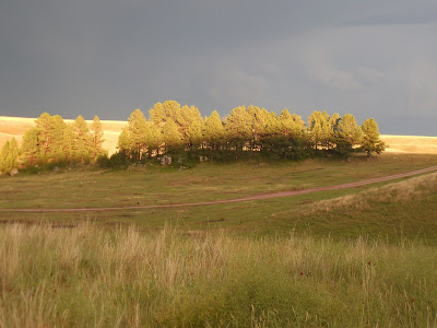
After the storm we set up camp. Soon after Mike commented that we hadn’t seen any bison, a herd made their way towards us. Park rangers always remind you to stay away from bison, but they never tell you what do to if bison come towards you. This herd chose to graze on the hillside across from our tents and we could hear many sets of hoofs stomping, mouths chomping, and lump-like bodies grunting. Eventually they grew bored of feasting on grass and shoved off. We were left alone in the dwindling daylight, a stunning alpenglow illuminated the hillside. Coyotes yipped, a badger squawked. It was a cool and peaceful setting for our first night.
~
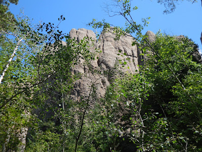
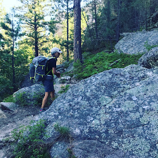
In the morning, Mike hiked out, and Jen and I marched on to images that we would come to see over and over again. Bluebird skies, big rock out cropping, tall flowing grass, sturdy ponderosa pines.
By the end of same day four, we reached the 40-mile mark. This was the most day days and most miles I had ever gone with a full pack, and I was holding up with no trouble. Day four was also our first resupply day. Mike cooked burgers for us while we washed clothes and relaxed. I was tired but content, and I slept well.
~
Day five began, and we continued to pass through the now familiar Black Hills landscape. Hot, open terrain and thankfully some shade. Smooth narrow singletrack, wide trails, some old double-track roads, rugged ATV tracks. Clusters of birch trees and raspberry patches. Head-high Jerusalem artichoke plants. A few cacti.
Along the trail we spotted deer, big horn sheep, mountain goats, and a few innocuous snakes but not many people. All told, we saw three sets of thru-hikers (Seven people), a smattering of ATV folks and a few day hikers near popular trails. We came across one pair of horseback riders, along with pair of mountain bikers and one runner towards the end of the trail.
Motorcycles were around, and we could hear their roar at many points but it was nothing more than white noise. The whirl of helicopters as we got nearer to Mt. Rushmore was louder, more persistent and more annoying than the motorcycles.
~
I’m used to backpacking up big vertical distances in Montana, but these climbs are usually in one big push. The up and down nature of the Black Hills was tougher than I had excepted, and lack of water required me to carry more water than I was used to. My feet felt pounded by the end of each day, but I’m pleased to say they recovered nightly and I was ready to go each morning.
Day seven was resupply day two. We stayed at the Dalton Lake campground with some colorful, but
thankfully quiet, characters. We woke up to a chilly 42-degree morning, but strong coffee made in a moka pot was a treat, and a fresh fruit, granola and yogurt breakfast was a nice break from gloppy oatmeal.
thankfully quiet, characters. We woke up to a chilly 42-degree morning, but strong coffee made in a moka pot was a treat, and a fresh fruit, granola and yogurt breakfast was a nice break from gloppy oatmeal.
Day eight of our thru-hike began and we passed the 100-mile mark that day. As Jen and I got closer to Sturgis, we started to catch glimpses of the prairie. Before we knew it, it was the last night of the thru-hike and we spent it in a nice, quiet campground offering shaded tent sites near the creek.
We began our last day at 5:45 a.m. on a peaceful, cool morning. Our end point, the summit of Bear Butte, was silhouetted in the early morning light and seemed a million miles away.
One foot in front of the other, step by step. We kept moving. Pretty views of rolling terrain pleased our eyes, but Bear Butte was still far off. After Fort Meade, we passed through a pasture where we circumnavigated a large herd of cows. From there it was long, open double-track all the way to Bear Butte Lake. The butte itself, looming 1,600 vertical feet skyward, was finally getting close.
Jen and I rested in the shade at the trailhead where Mike met us for the push to the top. The day was heating up, and Bear Butte was totally exposed, roasting in the sun. But we ready to be done with it. Only 2.8 miles left. Straight up we went.
Heat radiated, sweat poured, my feet barked at me. Loose, skittery rocks lined the steep trail but soon we were on top. On the summit, colorful snippets of fabric were tied to trees - ceremonial prayer flags and tobacco pouches left at this site sacred to Native Americans. A viewing platform offered a 360-degree panorama of the Black hills, the prairie, farms and the town of Sturgis. Glorious.
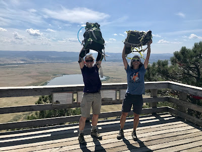
Jen and I hoisted our packs overhead for an obligatory summit photo. When I though of this moment throughout the hike, I wondered if I might cry or if I would be buzzing with frenetic energy. Maybe I'd have some sort of life-changing thru-hike epiphany. When I found myself there, I was elated but in a subdued, mellow way. I felt invincible.
Centennial Trail officially starts and ends at the summit of Bear Butte, so we added 2.8 miles to our 124-mile hike. Back at the car, we took off our hiking shoes and reclined in the shade before heading to Sturgis for a celebratory cone of soft serve ice cream.
~
If You Go
Direction of travel – We hiked South to North. It’s about 2,000 vertical feet less than the opposite direction and you end, rather than start, on the summit of iconic Bear Butte.
Books, Maps, Itinerary
- National Geographic Black Hills North and Black Hills South maps
- Hiking Centennial Trail: A Guide to Hiking South Dakota's Centennial Trail by Cheryl Whetham and Jukka Huhtiniemi breaks the trip down into 19 sections. It provides a lot of useful information and is small enough to take with you.
The book, however, doesn’t give advice on itineraries for thru-hikers. An itinerary is easy to figure out using the book, but I’ve included our breakdown below. Additionally, water can be sparse along the trail and is a factor as you work out logistics. Again, you can figure this out using the book, but I’ve shared what we found.
Day 1 (Half Day) – Norbeck in Wind Cave National Park to Highland Creek –Park rangers told us Highland Creek might not be flowing or it might be contaminated from bison, but it was flowing and looked clean. Either way, it’s a short day so easy water-wise.Day 2 – Highland Creek to French Creek Natural Area – There’s water about halfway through the hike and a spigot at the French Creek horse camp towards the end. You can camp at the horse camp in a nice shady spot away from the big horse trailers, but we went a few tenths of a mile beyond to camp in the natural area.Day 3 – French Creek to Black Elk Wilderness – Water at lake in the middle of the hike.Day 4 – Black Elk Wilderness to Samelius Trailhead – Easy water day. Mike met us for a resupply.Day 5 - Samelius to Brush Creek – Water at Sheridan Lake the first half of the hike. Interestingly, the book mentioned an always reliable cattle trough on a ranch, which sounded icky but was surprisingly clean looking. You can avoid carrying a lot of water if you use this.Day 6 – Brush Creek to Pilot Knob – Water at Rapid Creek, a few miles into the day. You can camp and get water at Jim Creek.Day 7 – Pilot Knob to Dalton Lake – Easy water day. There is a creek in middle of the hike. This was also our second resupply.Day 8 – Dalton Lake to Elk Creek – Elk Creek can be dry or raging (There are ropes for crossing but you’d probably want to take the six-mile detour during high-water). We couldn’t get any info on the current condition of the creek so we filled up with water in the morning. We found Elk Creek to be flowing but a bit gritty.Day 9 – Elk Creek to Alkali Creek – Bring a lot of water. No water until the spigot at the campground at the end of the hike. There is a great campground at Alkali Creek. The book mentions it is closed during the Sturgis rally and the week that follows, but it was open (we arrived on the last day of the rally) and surprisingly quiet. Tent sites are secluded and near a creek.Last day – Alkali Creek to Bear Butte –Water at campground in morning and Bear Butte Lake campground before the summit. This was our longest day (17 miles) and the most vertical feet in one push (1,600 feet in 2.8 miles).
About the Trail
- Not huge vertical on paper but many rolling ups and downs made it harder than it first appears.
- The Centennial Trail is not a wilderness trail, but it was surprisingly free of people.
- Horses – There are two very nice horse camp along the trail but we saw only one couple on horseback. The trails were not as horse trampled as the ones you sometimes find near popular guest ranches. And they were surprisingly free of manure. If you’re prissy like me, these things are appreciated.
- There are no bears on the Centennial Trail so food storage is much easier than I'm used to. This was handy.

Thru-Hiking Tips - Some basic backpacking tips that were emphasized during my first-thru-hike plus some new info.
- One-gallon zip-lock bag mostly filled with food (Not including evening meals but including oatmeal for the morning) will be enough food for four days
- A rope is a nice thing to have for hanging clothing
- Safety pins are handy
- I was reminded that it is easy to get very cold after a thunderstorm. I was shivering after the storm on day one. Don’t skimp on a warm layer.
- The trip was challenging but entirely do-able. A really short day or even a rest day sometime around day five to seven would have been nice.
~
More posts about backpacking and exploring
- Random lakes in the Madison Range - http://annvinciguerra.blogspot.com/2016/09/random-lakes-madison-range.html
- A hiking adventure on Montenegro's 751 trail - http://annvinciguerra.blogspot.com/2015/11/taking-long-way-around-hiking-adventure.html
- Sky Rim Trail, Yellowstone National Park - http://annvinciguerra.blogspot.com/2015/08/an-overlooked-gem-sky-rim-trail-in.html




Thank you for this information! I intend to also thru-hike the Centennial Trail within the next two years. Heather (aka Mayflower)
ReplyDeleteThanks for checking out my blog Heather - reach out if you ever have questions about the Centennial Trail. I really enjoyed it.
DeleteThanks for sharing! I’m planning a thru hike in 10 days later in the summer as well. This info and itinerary you provided are spot on for what I need!
ReplyDeleteI'm glad I could help Lox. Thanks for checking out my blog. Enjoy the Centennial Trail and let me know how it goes.
Delete